San Antonio International Airport (SAT)
Orientation and Maps
(San Antonio, Texas (TX), USA)
One of America's biggest cities, San Antonio tends to be a fairly relaxed city, in spite of its size and importance. San Antonio is famed for its 'Tex-Mex' cuisine and whilst much of the city spreads outwards, the downtown district is fairly compact and easily walkable.
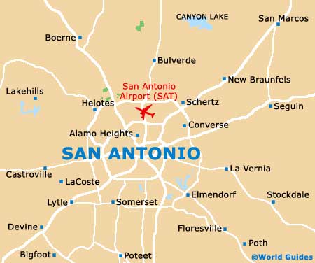
Directly north of the city center, San Antonio International Airport (SAT) is situated close to the intersection of the US-281 highway and the Loop 410. City buses connect the airport with the downtown district and run at 45-minute intervals during the busiest hours.
Many people also arrive in the city of San Antonio on Greyhound buses and the terminal is located along St. Mary's Street, being shared with Kerrville Bus Lines. The city's bus system is operated by VIA. Route maps are available at the information center on East Houston Street. San Antonio's Amtrak and Texas Eagle trains all run to and from the station on Hoefgen Avenue.
San Antonio International Airport (SAT) Maps: Important City Districts
An integral part of downtown San Antonio, the Riverwalk is a particularly scenic way to sightsee and is located along the banks of the city's canal. Often known as the 'River City', San Antonio enjoys a fairly central situation in the state of Texas and is just a short drive from Austin, the Hill Country and even Houston.
The Alamo is located close to the very center of downtown San Antonio and is one of the city's top attractions, dating back to the beginning of the 18th century. On the southern side of the Alamo, a trail links the city's four other missions, which combined, are part of the San Antonio Missions National Historic Park.
USA Map

Texas Map

San Antonio Map